inquiry
Leave Your Message
0%

You know, the rapid progress in Global Navigation Satellite System (GNSS) tech has really changed the game when it comes to accurate positioning and mapping. One of the big players in this? Continuously Operating Reference Stations, or CORS for short, which are basically stations equipped with GNSS gear that keep running all the time. According to a report from the U.S. Department of Transportation, popping these CORS stations into the mix can boost the accuracy of Gnss Positioning to within just a few centimeters. That’s huge, especially when it comes to surveying, farming, or building projects.

As cities get more and more complicated and everyone needs better geographic data, CORS stations become absolutely vital. Studies, like those from NOAA, highlight how these networks give us dependable data for real-time kinematic (RTK) positioning, which can get us within 1 or 2 centimeters of the real location. That kind of precision doesn’t just make maps look better; it really helps with collecting data across so many industries, leading to smoother operations and smarter decisions.

Looking ahead to 2025, it seems like making the most of CORS GNSS will be key in tackling the tricky challenge of Precise Positioning in different fields. With tech getting better all the time and more CORS networks popping up worldwide, folks involved in mapping and data collection should really consider jumping on this bandwagon. Embracing these advancements could keep them ahead of the curve and better equipped to meet the ever-changing demands of their work.

2025 How to Utilize Cors Station Gnss for Accurate Positioning and Mapping

Introduction to Cors Station GNSS Technology

2025 How to Utilize Cors Station Gnss for Accurate Positioning and Mapping

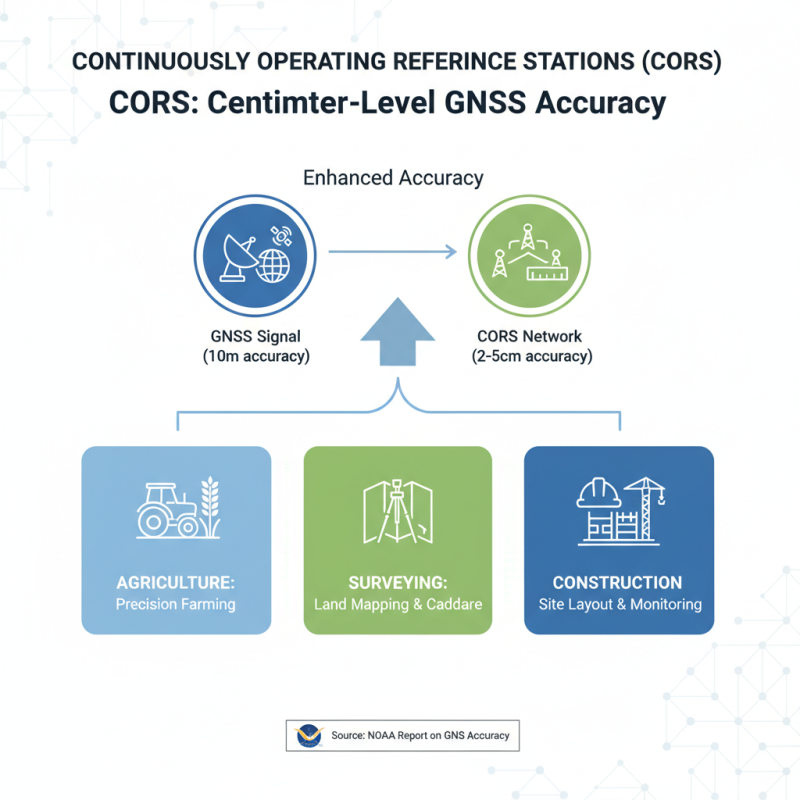
In recent years, Continuously Operating Reference Stations (CORS) have emerged as a pivotal technology in the realm of Global Navigation Satellite Systems (GNSS), enhancing the accuracy of positioning and mapping applications. CORS utilizes a network of fixed, ground-based stations to provide real-time data corrections to GNSS signals, significantly improving positioning accuracy to a few centimeters. According to a report by the National Oceanic and Atmospheric Administration (NOAA), CORS networks can enhance GNSS positional accuracy from an average of 10 meters to just 2-5 centimeters, making them essential for various applications in agriculture, surveying, and construction.

One notable application of CORS technology is in precision agriculture, where farmers employ GNSS-based systems for better field management. With the accuracy provided by CORS, farmers can optimize planting patterns, monitor crop health, and minimize resource waste. A study from the International Journal of Precision Agriculture indicates that the implementation of CORS for such applications can lead to yield increases of up to 15%, showcasing the tangible benefits of harnessing this technology.

**Tips:** When utilizing CORS for mapping and positioning, ensure that you select a station that is geographically close to your area of work to minimize error. Additionally, regularly check for station maintenance updates to guarantee the reliability of the data you are receiving. Implementing these strategies will enhance the overall effectiveness of your GNSS applications.

Key Components of Cors Station GNSS Systems

The utilization of Continuously Operating Reference Stations (CORS) in Global Navigation Satellite System (GNSS) facilitates high-precision positioning and mapping. Understanding the key components of Cors Station Gnss systems is essential for harnessing their full potential. Primarily, a CORS station includes a high-quality GNSS receiver, which collects data from multiple satellite signals. The accuracy of positioning largely depends on the receiver's ability to process signals from various satellites, thereby minimizing errors caused by atmospheric disturbances, multipath effects, and satellite clock inaccuracies.

In addition to the GNSS receiver, an effective CORS system incorporates robust data processing capabilities. This often involves real-time kinematic (RTK) algorithms that provide centimeter-level accuracy by comparing data from the CORS station with data collected from Mobile Gnss receivers. The CORS infrastructure also includes communication systems that transmit correction data to users in the field, enhancing the positioning accuracy of their devices significantly. Furthermore, having a reliable power supply and a well-organized maintenance schedule ensures continuous operation and data availability, which are critical for applications such as land surveying, agriculture, and geospatial mapping. These components work together to create a comprehensive system that maximizes the effectiveness of GNSS technology in various positioning applications.

Utilization of CORS Station GNSS for Accurate Positioning

This chart illustrates the accuracy levels of CORS Station GNSS systems in different environments. As shown, urban areas present more challenges compared to rural settings due to signal reflection and obstructions.

Benefits of Using Cors Station GNSS for Positioning

The integration of Continuously Operating Reference Stations (CORS) in Global Navigation Satellite System (GNSS) technology presents significant advancements in achieving accurate positioning and mapping. According to a report by the National Oceanic and Atmospheric Administration (NOAA), CORS networks have been successfully utilized to provide real-time kinematic (RTK) positioning with accuracy levels often less than 2 centimeters. This degree of precision is essential for applications ranging from land surveying and construction to geospatial analysis and environmental monitoring.

One of the primary benefits of using CORS station GNSS for positioning is the enhancement of data reliability. A study published by the National Geodetic Survey in 2022 highlighted that utilizing CORS data effectively reduces positioning errors caused by atmospheric conditions and satellite geometry. The network continuously collects data, allowing users to access corrected GNSS signals that account for these variabilities, resulting in improved overall accuracy. Furthermore, the efficiency of reduced calibration times and minimized need for local base stations makes CORS systems an attractive choice for professionals in the field, streamlining their workflows and reducing costs associated with traditional positioning methods.

2025 How to Utilize Cors Station Gnss for Accurate Positioning and Mapping - Benefits of Using Cors Station GNSS for Positioning

Parameter Description Benefit Use Cases
Accuracy High precision position data Enables precise mapping and land surveying Construction, Agriculture
Real-time Data Continuous stream of positioning data Immediate response for dynamic applications Surveying, Emergency Response
Cost-effective Reduced operational costs Minimize need for expensive equipment Land Surveying, Civil Engineering
Flexibility Adaptable to various needs Future-proof solution for different sectors Environmental Monitoring, Mining
Scalability Expand as needed Easily accommodates growth in projects Urban Planning, Infrastructure Development

Steps to Set Up a Cors Station GNSS for Mapping

Setting up a CORS (Continuously Operating Reference Stations) GNSS for mapping requires careful planning and execution to ensure accurate positioning.

The first step is to select a strategic location for the CORS station, ideally in an area with minimal obstructions such as tall buildings or trees that could interfere with satellite signals. Ensure the site has a clear view of the sky to maximize satellite visibility for optimal accuracy. Once the location is chosen, install the GNSS receiver securely and connect it to a stable power source, which is essential for continuous operation.

The next phase involves configuring the CORS station for optimal performance.

This includes setting up communication protocols to transmit data to users effectively. Make sure to calibrate the equipment regularly to avoid any discrepancies in the data collected. Additionally, establish a routine for monitoring the station's performance and connectivity to satellite networks. By ensuring that the station is operational and well-maintained, users can benefit from precise and reliable positioning data for mapping projects, enabling accurate geospatial analysis and decision-making.

Best Practices for Ensuring Accurate Measurements

The utilization of CORS (Continuously Operating Reference Stations) in GNSS (Global Navigation Satellite System) technology is essential for achieving precise positioning and mapping. According to a recent report by the National Geodetic Survey, the introduction of CORS networks has improved the accuracy of measurement data by up to 50% when compared to standalone GNSS systems. Utilizing multiple reference stations can mitigate the effects of atmospheric disturbances and provide real-time correction data, significantly enhancing reliability in various applications such as land surveying, construction, and agriculture.

To ensure accurate measurements with CORS stations, practitioners should follow best practices. First, users should select the nearest CORS station to their project area to minimize potential errors caused by signal dissipation. Additionally, regularly calibrating equipment and validating data against known benchmarks can help maintain accuracy over time. The integration of precise GNSS receivers and antennas optimized for multipath mitigation can further enhance positioning reliability.

Tips: Always monitor satellite visibility and select optimal times for data collection when satellite geometry is favorable. Engage in continuous training and utilize the latest GNSS processing software to stay updated with evolving technologies. By adhering to these best practices, professionals can leverage CORS stations effectively for high-precision results.

Applications of Cors Station GNSS in Various Industries

The implementation of CORS (Continuously Operating Reference Stations) Station GNSS technology has profound implications across various industries, particularly in precision-driven fields such as agriculture, construction, and transportation. In agriculture, farmers leverage GNSS for precise field mapping and crop monitoring. By utilizing real-time kinematic (RTK) positioning data from CORS stations, they can enhance planting accuracy and optimize resource allocation, leading to improved yield and minimized environmental impact.

In the construction industry, CORS Station GNSS is essential for site surveying and project management. Engineers and surveyors utilize the accurate positioning data to ensure that construction plans align perfectly with geographical coordinates. This precision reduces errors, enhances safety, and streamlines workflows, ultimately leading to timely project completion. Additionally, the transportation sector benefits greatly from GNSS technology, as it allows for effective fleet management and route optimization, which contributes to reduced fuel consumption and enhanced delivery efficiency.

Overall, the diverse applications of CORS Station GNSS in these industries highlight its role as a cornerstone technology for achieving accurate positioning and mapping, driving innovation and efficiency in modern operations.

Future Trends in Cors Station GNSS Technology and Positioning

2025 How to Utilize Cors Station Gnss for Accurate Positioning and Mapping

The future of CORS (Continuously Operating Reference Stations) in GNSS (Global Navigation Satellite System) technology promises remarkable advancements in precise positioning and mapping. As urban areas expand and the demand for accurate geospatial data increases, CORS stations are becoming indispensable. According to the International GNSS Service (IGS), the accuracy of GNSS positioning services has improved to within centimeters, allowing for more reliable applications in surveying, construction, and environmental monitoring. A report from the National Oceanic and Atmospheric Administration (NOAA) indicates that the proliferation of CORS networks is driving a shift towards real-time kinematic (RTK) positioning, which can enhance accuracy to millimeters.

To tap into the potential of CORS stations, users should focus on integrating enhanced data processing techniques and adopting multi-constellation GNSS solutions. This approach not only improves the robustness of positioning but also minimizes errors caused by atmospheric disturbances and obstructions. An emerging trend is the integration of Artificial Intelligence (AI) in GNSS data processing, which enhances the predictive capabilities of positioning algorithms and optimizes network resilience.

Tips: When utilizing CORS stations, ensure your equipment is compatible with multiple GNSS constellations for optimal results. Regularly update your software to leverage the latest advancements in GNSS technology. Additionally, consider collaborating with local agencies that operate CORS networks to gain access to the most accurate and timely data.

FAQS

: What are the primary benefits of using CORS station GNSS for positioning?

: The primary benefits include enhanced data reliability, reduced positioning errors caused by atmospheric conditions and satellite geometry, improved accuracy often within 2 centimeters, and decreased calibration times, which streamline workflows and reduce costs compared to traditional methods.

How does CORS station GNSS improve accuracy in agriculture?

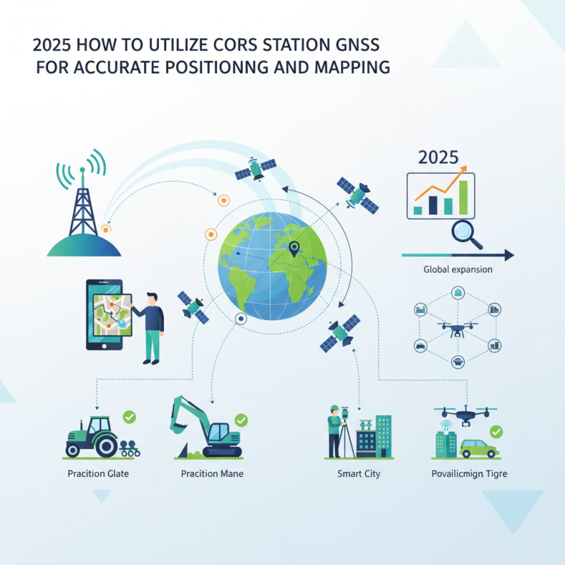
In agriculture, CORS station GNSS provides real-time kinematic (RTK) positioning data that allows farmers to achieve precise field mapping and crop monitoring, enhancing planting accuracy and optimizing resource allocation, which leads to improved yield and reduced environmental impact.

In what ways is CORS station GNSS utilized in the construction industry?

CORS station GNSS is used for site surveying and project management in construction to ensure that plans align with geographical coordinates accurately, thereby reducing errors, enhancing safety, and streamlining workflows for timely project completion.

How does CORS station GNSS contribute to transportation efficiency?

CORS station GNSS supports effective fleet management and route optimization in the transportation sector, leading to reduced fuel consumption and improved delivery efficiency.

What future trends are anticipated in CORS station GNSS technology?

Future trends include advancements in positioning accuracy to within millimeters, increased integration of enhanced data processing techniques, the adoption of multi-constellation GNSS solutions, and the application of Artificial Intelligence in GNSS data processing for improved predictive capabilities.

What equipment considerations should users make when utilizing CORS stations?

Users should ensure their equipment is compatible with multiple GNSS constellations, regularly update their software to utilize the latest advancements in GNSS technology, and consider collaborating with local agencies operating CORS networks for access to accurate and timely data.

Why is the integration of CORS networks becoming more vital as urban areas expand?

As urban areas expand, the demand for accurate geospatial data increases, making CORS networks indispensable for providing precise positioning and mapping essential for various applications in surveying, construction, and environmental monitoring.

How do CORS stations reduce the errors in positioning signals?

CORS stations continuously collect data, providing access to corrected GNSS signals that account for atmospheric conditions and satellite geometry variabilities, thus reducing positioning errors significantly.

What role does real-time kinematic positioning play in CORS GNSS?

Real-time kinematic (RTK) positioning enhances accuracy to millimeters, making it essential for applications requiring high precision, thereby driving advancements in fields like surveying and construction.

How can users optimize the use of CORS station GNSS in their operations?

Users can optimize their use by integrating enhanced data processing techniques, adopting multi-constellation GNSS solutions, ensuring equipment compatibility, and collaborating with local CORS network agencies for better access to data.

Conclusion

The article "2025 How to Utilize Cors Station Gnss for Accurate Positioning and Mapping" explores the innovative technology of Cors Station GNSS, which significantly enhances positioning accuracy and mapping capabilities. It provides an in-depth look at the key components of Cors Station GNSS systems, highlighting how they function and the advantages they bring to various industries, including surveying, agriculture, and construction.

Furthermore, the article outlines practical steps for setting up a Cors Station GNSS for effective mapping, emphasizing best practices for ensuring accurate measurements. It also discusses the diverse applications of this technology and considers future trends that may shape the evolution of Cors Station GNSS in the coming years, ultimately positioning it as a vital tool for precision in spatial data collection and analysis.

Samantha

Samantha

Samantha is a dedicated marketing professional at Shanghai Apekstool (APEKS), a leading provider of innovative geospatial surveying and mapping products based in Shanghai, China. With a deep understanding of the industry, she excels in promoting the company's core offerings, which include......
Previous Top 10 RTK Col Antenna Manufacturers from China at the 137th Canton Fair